Nature— summer
Hiking in Tohoku: Five Trails That Belong on Every Serious Walker's List
May 28, 2026
Tohoku's mountains are among Japan's finest and least crowded. Here are five trails that reward the effort, from sacred pilgrimage routes to volcanic crater rims.
Japan's hiking culture is well-developed and internationally known. Fuji draws 220,000 climbers per season. The Kumano Kodo pilgrimage route has a UNESCO designation and a waiting list at the best waystation lodges. The Northern Alps attract technical climbers from across Asia.
Tohoku's mountains attract almost none of this attention, despite containing trails that are more varied, more atmospheric, and less crowded than anything in the more famous ranges. This is not a modest claim — the Oirase Gorge trail is one of the finest forest walks in Japan, the Dewa Sanzan circuit is a living spiritual tradition, and the crater of Mount Zao offers a landscape that exists almost nowhere else on Earth. The reason they remain undervisited is simply that the mountains of Tohoku have not been marketed internationally.
Oirase Gorge: The Forest Walk
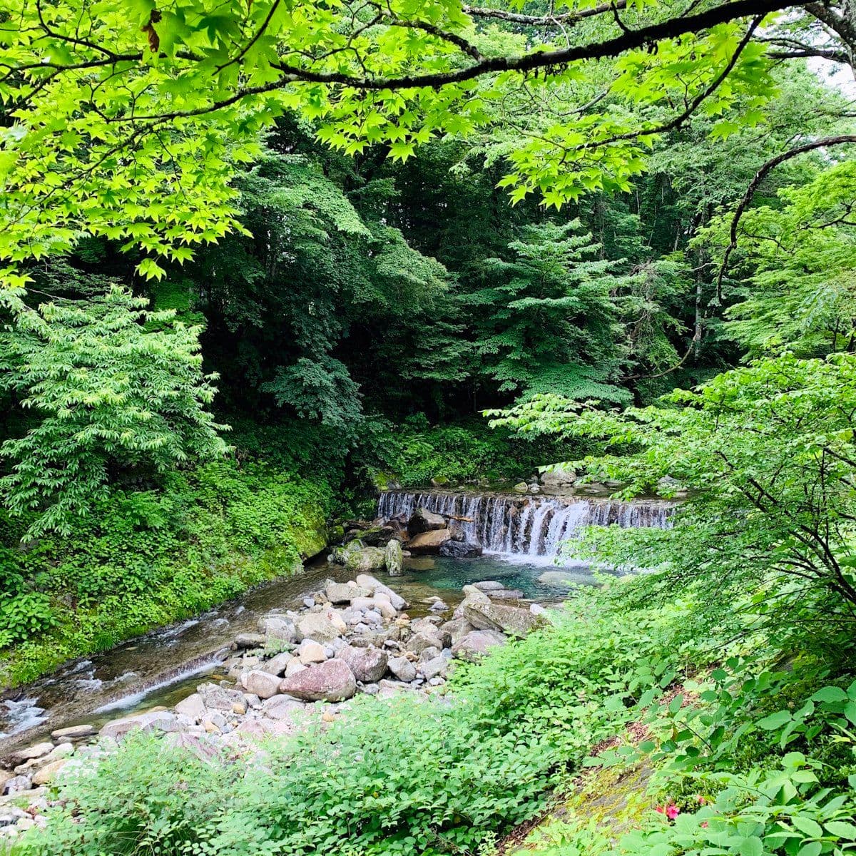
The Oirase Gorge trail runs 14 kilometres along the Oirase River from Yakeyama to Lake Towada. It is the most accessible trail on this list — flat, well-marked, no technical difficulty — and among the most rewarding. The old-growth forest on both sides of the river creates a canopy so dense that the trail is navigable even in light rain. Fourteen numbered waterfalls fall into the river along the route; the largest, Choshi Otaki, drops 7 metres over a broad face of volcanic rock.
Best season: autumn (mid-October to early November), when the maple and beech canopy turns amber and red above the river. The colour change in the gorge is gradual and consistent — you can walk through five distinct phases of autumn colour in a single day. Spring, when snowmelt feeds the river and the forest floor is carpeted in wild flowers, is the second best season.
Practical: buses run along the gorge road from Towada city and from the Lake Towada visitor center, allowing point-to-point hiking. Starting from Yakeyama (the lower end) and hiking upriver to the lake takes 4–5 hours. The road beside the trail is narrow and carries cars; the most pleasant sections of the trail diverge from the road into the forest.

Nature
Dewa Sanzan: How to Walk Japan's Most Sacred Pilgrimage Route
Three sacred mountains. 1,400 years of pilgrimage. The Dewa Sanzan circuit in Yamagata is Japan's most spiritually charged walking route — and one of its least internationally known.
Dewa Sanzan: The Pilgrimage Circuit
The three mountains of the Dewa Sanzan — Haguro-san (419m), Gas-san (1984m), and Yudono-san (1504m) — form a circuit that has been walked by mountain ascetics (yamabushi) for 1,400 years. Completing the full circuit requires two to three days and a level of physical preparation appropriate to a serious mountain hike. Individual mountains can be done as day trips.
Haguro-san, the lowest and most accessible, is entered via a 2,446-step stone staircase through old-growth cedar forest. The oldest trees are more than 400 years old and stand in clusters at the base of the steps. The Five-Story Pagoda (1372) stands in a clearing partway up — one of the finest examples of old Japanese pagoda architecture in the north. Summit shrine and tea houses at the top.
Gas-san is the high point. The approach from the eighth-station trailhead (bus from Tsuruoka) passes through alpine wetland, snowfield (possible until late June), and high moorland before reaching the summit shrine complex. The descent toward Yudono-san is steep and requires care on loose rock. Most hikers take the two-day version, staying at the summit mountain lodge (Gassan Chojo Goya).
Mount Zao: The Crater Lake Walk
The Zao volcanic massif straddles the Miyagi-Yamagata border. The approach from the Yamagata side uses a ropeway (two stages) to reach the upper slopes, from where a trail leads to the active crater — Okama, which translates as "the cooking pot." The crater contains a lake of startling colour: green in summer from the acidity, which shifts toward blue under certain lighting conditions. The colour is created by dissolved minerals from the active vents at the lake's base.
The walk around the crater rim takes approximately 40 minutes. The terrain is volcanic rock — exposed and windy at elevation. The full Zao traverse (crossing from the Yamagata side to the Miyagi side via the crater) takes 5–6 hours and requires a car shuttle or a lengthy road return.
Hayachine-san, Iwate: The Flower Mountain
Hayachine-san (1,917m) in Iwate is one of Japan's 100 Famous Mountains. Its upper slopes are famous in the Japanese botanical world for a concentration of endemic and rare alpine plants that have been documented since the 19th century. In July and August, the flowering season produces a carpet of species found nowhere else at this density outside of Hokkaido.
The approach from the Ōshuku road head takes 4–5 hours to the summit. The trail passes through lower forest, then open ridge, then the high alpine zone where the endemic flowers are concentrated. The descent by a different route creates a full loop of approximately 9 hours.
Shirakami-Sanchi Border Walk
The Shirakami-Sanchi UNESCO World Heritage forest straddles the Aomori-Akita border. The Juniko (Twelve Lakes) area on the Aomori side is the most accessible entry point — a cluster of deep-green pools in beech forest, served by a forest trail network. The core zone of the Shirakami-Sanchi — the ancient, unmanaged beech forest — requires a permit and a guide to enter.
The most rewarding accessible route: the Juniko forest walk (3–4 hours, circular) combined with the short trail to Aoike (the Blue Lake), where the water reaches a depth and clarity that gives it an implausible turquoise colour in afternoon light. Best in September–October for beech foliage.